Friday, August 29, 2014

National Carvers Museum whittled down to splinters and memories


One dark day in April, 1990, the ornately carved doors were closed to the public forever


By Rob Carrigan, robcarrigan1@gmail.com

Ornate totem poles, jutting skyward 20 feet in air, once marked the turnoffs from the field at the corner of Baptist Road.
Tourists, from all over the nation (and in fact the world) would stop to view the carvers' craft gathered on 11 acres — and more than 7,000 wood carvings from every state in the union.
Then one dark day in April, 1990, the ornately carved doors were closed to the public, forever.
"The National Carvers Museum, which hosted carvings from around the country for 15 years, is probably closed for good," leads the Tribune, in the April 26, 1990 edition.
"Unless we can find a rich widow willing to give us a million dollars, I don't see us opening again," the Tribune article quotes Rich Wetherbee, president of the board then.
Board members and those associated with the museum, said that bonds and loans issued to build and maintain the facility south of Monument, and high operating expenses drained the museum's treasury.
The board also canceled the May printing of 'The Mallet,' the museum's monthly publication that went out to 3,200 members. There are also 1,200 honorary life members, according to the Tribune article.
The museum had grown from its incorporation in 1969 to one with 7000 articles in it worth nearly $1 million, according to one of the founders.
Harry Meech, who was one of the founders of the museum, reacted with bitterness toward the move.
"I ran it for 15 years, and then in six months they file for bankruptcy," said Meech who had retired in the previous October. 
However, John Corff, the museum director at the time of closing, indicated after taking over for Meech, the museum faced a long financial road.
"He cited $800,000 in bonds that needed to be paid off in 10 years, omitting at the same time any interest payment. Interest on the bonds run as high as 16 percent on some of the bonds that are unsecured with any property, the paper reported.
"Bond holders are already getting uneasy, with two suites against the museum, one for $35,000 and the other for $7,000. There is also an $185,000 mortgage on the building that costs the board $2626 per month," Tribune said.
"Corff told the membership that the board needed over $400,000 in income to 'keep the doors open."
Revenues in 1988 were just over $280,000. In addition, the board has just over $300,000 in notes that were secured by certificates of deposits, or CDs, reported the paper then.
In taking the bonds and notes, the board is facing payment of $1.4 million though 1994 if it paid off bonds and interest on notes, a reconstruction of records showed. Even with payment of the $1.4 million, the $300,000 in notes would remain after 1994.
In trying to keep the doors open, Corff and the board devised subscription plans that changed the life-time membership arrangement of many members who paid $100 a few years ago to assure them a free mallet subscription.
Life membership went to $150 with the Mallet subscription going to $15 per year after the first year. Life member were required to pay an additional $50, but less than $1,000 paid the additional amount, said one board member at the time.
"There is just not enough carvers to go around to support a national museum," said board member Fred Clark, who moved to Monument from New York to be near the museum.
But there was some bitterness from some of the board members, too, citing bad business practices of selling bonds and getting the museum in over its head. 
Meech said the bonds were sold before the museum opened as a way of financing a dream. 
"People kept telling me it was possible to sell bonds. We got an attorney and received a license to sell the bonds," he said.
Meech and Lawrence Martin of Chicago, acquired the acreage just off Baptist Road and said at one point, he personally acquired 600 of the carvings. The museum building was built in 1973. Later, an educational building, named in honor of Meech and his wife Vivienne, was also constructed.
Meech was working at a Chicago electric utility until he moved to Colorado to work at the museum, according to an earlier Tribune article six months prior to the closure. 
"He served as administrator, publisher-editor of "The Mallet" and elected to the board seven times. His wife worked as member director for nine years without compensation," the article about Meech's retirement said.
"I just feel personally sad, After all these years, now we tear it down." 
But they didn't tear it down. 
Today Wood Carvers Properties houses NavSys and the Tri-Lakes Business Incubator. Alison Brown is the CEO of NavSys and president of the Incubator, and said the property was purchased from the banks in the early 1990s using a special loan program though the Pike Peak Regional Development Authority.
Brown donated the ornately carved doors to the city of Monument, and several years ago, when the new town hall was constructed, the doors were used in Board of Trustees Chambers.
Brown said for about 10 years, after the closure of the museum, people still came by asking about it. 
"It didn't help that the Denver Post listed it for several years following in the Top 25 Things not to Miss in Colorado. "
For many years, a sign designated the National Carvers Museum, along with the altitude, though Brown, who is an international expert in GPS systems, noted that altitude was wrong. "I think it was several thousand feet off," she said.
Today, editions of "The Mallet" and memorabilia of the long-lost museum are sold and traded on E-Bay, and a photographic tour of the facility as it was in 1984 is available at http://www.richardstamats.com/NCM/index.html.

Photos 1,2, 3:

Alison Brown donated these hand-carved doors to the city of Monument when she purchased the the former National Carvers Museum property in the early 1990s. The doors display carvings of all 50 states and open into Council chambers at City Hall. The carver's signature, Tim Weberding, of Batesville, Indiana, is on one corner.


Photos 4,5,6,7
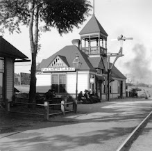
The gazebo at the former National Carvers Museum, though weathered by the years, still sports various carvings from the heyday of the internationally-known attraction.


By Rob Carrigan, robcarrigan1@gmail.com

Thursday, August 21, 2014

Taking care of business with a button


“Computers are useless. They can only give you answers.”
― Pablo Picasso


Merton believed in technology, he just didn't like to deal with it.


By Rob Carrigan, robcarrigan1@gmail.com

Years ago, you couldn't talk to Merton Taylor on Monday afternoons.
He would hole himself up, back at the check-in stand, working on an order for Amarillo Hardware's truck coming in on Thursdays. Mostly, he would cuss the state of the nation, slur half the people in that nation, and then start in on the other half.
But the biggest problem with the world at that time, according to him, was technology.
Having experienced the turmoil he went through dealing with a microfiche reader, I can't imagine what kind of cussing would have went on — if he had to deal with the Internet.
Merton believed in technology. He just didn't like to deal with it.
Those were different days.
The Post Office and the Bank were on opposing corners of the center block of Sixth Street, and business was still a face-to-face affair in our little town. Every day, at 11 a.m. and 4:30 p.m., the entire population would converge between the two landmarks and do that business.
Though, Merton often sent a 'red dog' representative to conduct his.
Which means, one of his Irish Setters took the bank bag down and dropped it off with a teller, (slobber and all) with someone following to take care of the paper work.
But, back to the technology.
World War II was the last time any of this technology crap made sense, he said.
And to prove it, he would have you mark every one of any of the 40,000 common retail hardware items in Taylor Hardware, via black or red grease pencil, with his own secret cost code, that took employees about seven years to learn how to read.
That code had all kinds of blind alleys and blocks, repeaters and switches in it. It was similar to the one he used during the war, in the Philippines.
When I first worked there, the Amarillo Hardware salesman, carrying two leather-bound, foot-thick, catalogs (one in each hand suspended by tooled leather handles) into the store once a month, to take care of "problems."
Seems like there was always a "problem" or two to resolve.
The rest of the time, (weeks without a salesman) on Monday, Merton, after gathering up the seven or eight 'Want Books' off of counters throughout the store, creating a list, then would painstakingly look up and transpose numbers out of the microfiche cards.
Which was all well and good, as long as the 'fiche bulb didn't burn out. Or, the numbers matched up, or the quantities were acceptable, or the illustration correctly identified an item. All of whch, almost never happened.
But at least, at the end of the day, all five of the red dogs, and grey one, or perhaps a black one, would lumber out the side door after 5:30 p.m., load up in the old International Scout, frailest to most agile by order, and head home at the end of the day.
Ready to come back and do the same thing tomorrow.
Still, it is sort of like that today, with the use of computers, the Internet, and all business taken care of with a button. Maybe we haven't learned a thing in 40 years.
It is in this environment that I've have heard the common discussion among writers, and customers, sources, and co-workers, etc... the common discussion that goes something like this.
"You can't talk to Rob Carrigan on Monday afternoons. He'll cuss the state of the nation, slur half the people in that nation ... then start in on the other half.
The biggest problem in the world today is technology.
I have the answers.  What we really need ...  the questions.


Sunday, August 17, 2014

Beacon tower blown to bits after move from Monument


You don’t miss something until it is gone


By Rob Carrigan, robcarrigan1@gmail.com

It is often true that you don’t miss something until it is gone. Sometimes you don’t even miss it then. That may be the case with the beacon light, of Beacon Lite Road fame, here in Monument.
Many years ago, I received fascinating copies of undated newspaper photos about the Beacon from reader Marianne Zagorski of Palmer Lake, and ever since that time I have been trying to nail down additional details and information.
Zagorski, who lived in Palmer Lake since the 1960s, said at the time, she thought the tower was taken down in the early 1980s.
 “As you’re coming up a long upslope on I-25 from Greenland, look for the beacon light on the right. Turn before you go west to Palmer Lake,” was directions she provided me but I have heard from other sources that it was roughly near where the two existing cell towers are today.
The captions from the photos were the attention getters.
“Aviation hazard – Two members of “C” Company, 4th Engineer Battalion from Fort Carson prepare to demolish a 110 foot tower Wednesday by climbing its base and planting explosive charges. The structure, considered a hazard to aviation, was destroyed as part of a military exercise,” read the cutline that apparently appeared in the Gazette Telegraph, crediting John Morgan with taking the photo.
“Going, going, gone. A little plastic explosive went a long way as a 110-foot tower was demolished in an exercise at Fort Carson. The tower was obtained in Monument and reassembled for a film by the British Broadcasting Company in April. With the film completed, the tower was no longer needed, so members of the 4th Engineer battalion ‘disassembled’ it in their own inimitable way,” read additional caption that appeared on a different page.
“By then we lived opposite the beacon and were disappointed and insulted by this use of it. Such a waste,” noted Zagorski.
Longtime area resident Dorothy Sibell recalled that the tower was removed using a helicopter but was at a loss to give a definitive date. Others recalled it was originally used as a marker to help locate an early airstrip in the area.
A few weeks ago, I stumbled on to this article in the June 12, 1980, Tribune under the headline "Beacon Tower to Be in a Movie."
Bill Kezziah was owner and editor of the paper then.
"It used to be a beacon, lighting the way for planes that flew down the Front Range from Denver to Colorado Springs during World War II. But now the beacon that sat atop and 80-foot tower on Monument Hill is no more. It has won fame of a different sort and with an ironic twist," said the article.
The tower was used in a movie the British Broadcasting Company was making of the well-known physicist J. Robert Oppenheimer.
"Some of the filming was made at Ft. Carson where the tower was moved and where it apparently will stay," the 1980 report said.
"The twist is that during the war, the tower and the beacon was a light to keep airmen from straying too close to the Front Range. But in the movie, the tower is the prop for the test of the atomic bomb. "
Jeff Tarbert, general manager of the Colorado Springs cable vision company that sold the Monument Hill tower to the movie makers is quoted at the time, "In fact, the tower is an almost exact replica of the actual test tower, although it is a little shorter."
The cable company purchased the land and the tower from Scott Ferguson in hopes of using it in the cable operation.
"Technical problems prevented its use for that, so when the broadcast company was casting around for a tower to be in the movie, a deal was struck."
According to the 1980 article, the movie production company was seeking buildings and other equipment to duplicate the Alamogordo, New Mexico site where Oppenheimer and the other scientists carried out their experiments. They found similar buildings at Ft. Carson.
"The production crew has moved from Ft. Carson, but an Army spokesman said the movie company donated the tower to Ft. Carson to be used as an observation spire."
Long-time Monument historian Lucille Lavelett noted the historical tie to the community in 1980 article, as the source for naming Beacon Lite Road, and recalled the name being changed in the early 1950s.

Top photo: The original beacon light was nearby where this cell tower stands today.

Bottom photo: Actually two towers, semi-disguised as tall pine trees, top Monument Hill and can be seen from the road.


Friday, August 15, 2014

Do wolverines live here in Colorado?


Haven't confirmed sightings

 By Rob Carrigan, robcarrigan1@gmail.com

They are dangerous, solitary, dark figures that wander long distances in high, lonesome, cold, difficult country. Like ghosts of mountain beasts past, or the Hugh Jackman character Logan, aka Wolverine, aka Stab Man, aka Knifey Boy, in world that never expected to see a big budget comic book movies again — they resurface out of nowhere.
My dad, a life-long resident of the state until his death in 2013, insisted that there are wolverines in Colorado. Not only that, but he claimed he had spotted the beast twice in the last few years.
“From an official standpoint,” noted Tyler Baskfield, spokesman for the Colorado Division of Wildlife, when I asked him about it several years ago, “They do not exist here in the state.”
“There are reported sightings throughout the state – mostly at higher elevations,” Baskfield acknowledges. The animals are difficult to document because “they roam 60 or so miles a day, that makes it hard to keep up with them.”

According to Colorado Parks & Wildlife's site today, it is still difficult to document them.
"There once was a viable population of wolverine in the state, however the last confirmed record was from 1919. Twelve survey efforts from 1979-1996 yielded no confirmed sightings. Colorado’s high elevation and rugged terrain were and are good wolverine habitat, but because the species naturally exists in extremely low numbers wherever it is found, the species was never numerous here. In 2009, researchers from Grand Teton National Park tracked a wolverine into northcentral​ Colorado. It is estimated that Colorado has the potential to support approximately 100 animals at full carrying capacity. Because the animal needs large areas of cold, rocky habitat, the vast majority of land where the animal would live occurs on high-elevation public lands." 
Not far from here, in February of 1966, came the report of the slaying of wolverine, at that time, the first verified in Colorado in more than 25 years.
“The animal was shot Friday by Roy Goecker of 4900 S. Wadsworth Blvd., Littleton, a professional guide, while he was hunting mountain lions along Pine Creek near Rampart Range in Douglas County,” wrote Al Nakkula of the Rocky Mountain News more than 48 years ago.
“Goecker told game officials his three hunting dogs came across the scent of the wolverine and pursued it into a rocky draw where the animal was cornered in deep snow. The guide said he was compelled to shoot the wolverine because of the known ferocious nature of the animal, to save his dogs.”
Nakkula’s Rocky Mountain News story at the time cited Herman Schultz, a wildlife conservation officer for the State Game, Fish and Parks Department, as saying the that the wolverine easily could have destroyed Goecker’s hunting dogs.
“He estimated the brown-black wolverine, a female about three feet long and weighing 21 pounds, was about 20 years old. Although the animal still had long sharp claws, her normal large fangs were nearly worn down to the gums because of age,” the report said.
According to San Francisco State University Department of Geography, the species officially named Gulo Gulo, but commonly known as wolverine, glutton, skunk bear, Indian devil, and carcajou, is a fairly elusive critter.
“Basic information on wolverine habitat relationships is almost non-existent,” says the University’s web site. “They generally inhabit areas above timberline, oftentimes preferring lower-elevation forests during winter. Wolverines occur in such low numbers across most of their remote habitat, and are so mobile; that it has been is extremely difficult to study them.”
“Healthy populations of wolverines appear to exist in Montana and Idaho, but scientists have been unable to locate populations in other plausible mountain locations, such as southwest Colorado or the Cascades of Washington,” says San Francisco State University’s site, “They have evaded trap and camera in California for over 75 years.”
The Department of Geography at Michigan State University (Wolverines) notes that extensive scientific efforts in California and Michigan have failed to prove that they still inhabit those states.
“Since 1979 Colorado wildlife officers have investigated more than 100 sightings and snow tracks, but by the time they return with a camera, the tracks have invariably drifted over. The closest they’ve come to a real wolverine was in 1982, when they nabbed an escapee from a Colorado Springs zoo who had gotten himself hopelessly tangled in a Denver window well,” according the Michigan State University’s Department of Geography web site.
The United States Fish and Wildlife Service (USFWS) announced on Aug. 12, that it has withdrawn the proposed rule to list wolverine as threatened in the contiguous United States under the Endangered Species Act (ESA). Colorado Parks and Wildlife (CPW) supports the USFWS for careful scrutiny of the available science on potential impacts of climate change on wolverine status, according to a release from CPW on Thursday, Aug. 14.
"CPW believes that state wildlife agencies within the wolverine range have developed conservation programs that are effective in maintaining wolverines within the lower 48 states, as evidenced by expansion in distribution of the species. The USFWS simultaneously withdrew a proposed “nonessential-experimental” population designation for the southern Rockies."
In July 2010, the Wildlife Commission (now the Parks and Wildlife Commission) authorized staff to begin having conversations with conservation partners and stakeholders about the potential reintroduction of wolverines. CPW intends to reconvene the stakeholder group and continue those discussions in light of the recent Federal decision not to list wolverine. Approvals to undertake a reintroduction would be necessary from the Parks and Wildlife Commission and the State Legislature.
"Historically, Colorado was home to wolverine, but due to trapping, predator control and other activities, the species was extirpated from the state. Although there are currently no documented wolverines in Colorado, the state has a substantial amount of high quality habitat, and there continues to be interest in wolverine conservation in Colorado," according to the CPW.
Prior to 2009, the last known wild wolverine in Colorado was recorded in 1919, says Matt Robbins of Colorado Parks and Wildlife. When I asked about the 1966 report, he checked into it, and said that in that instance, the wolverine turned out to also be an escapee from Cheyenne Mountain Zoo.
"The animal was not originally native here, but was moved in from another area."
And I guess  while we are talking about moving in ...

In June 2009, "M56," the moniker given to a male wolverine trapped and given an abdominal implant near Grand Teton National Park, was photographed in Rocky Mountain National Park.
"CPW biologists and pilots monitored his whereabouts and determined his locations for the next several years. In addition to being photographed in the park, he was photographed near Guanella Pass in April 2012. He was last located in October 2012. It is unknown why efforts to obtain additional locations were unsuccessful – he may have left the state or the battery in the transmitter may have died," Robbins said.

Wednesday, August 13, 2014

Incline to close for construction


Beginning Monday, August 18, the Incline will be closed for about four months as repair workers begin on a $1,586,486 improvement project. Construction is expected to be completed in December.
The project, according to city officials has four major goals: improved safety, enhanced user experience, long-term sustainability of the trail and increased accessibility.  
Work on the Incline will include repair and replacement of damaged retaining walls, cleanup of rebar and loose debris, construction of additional drainage structures, stabilization of existing ties and stabilization of surrounding slopes.  The new drainage structures will significantly reduce the velocity of water, a critical factor in reducing erosion and ensuring the Incline’s long-term sustainability. 
Funding for the project comes from the following sources:
• FEMA -$556,486
• Great Outdoors Colorado Grant - $350,000
• Colorado Springs Utilities - $250,000
• State Trails Grant - $200,000
• Colorado Springs CTF Program - $80,000
• Incline Friends - $60,000
• Colorado Springs TOPS Program -$50,000
• Manitou springs Barr Parking Lot Fund - $40,000
Area officials note that  during construction, Barr Trail, Ute Indian Trail, Interman Trail, Red Mountain Trail, and the COG Railway will remain open in their entirety.
"These facilities are within walking distance of the Incline and utilize the community shuttle stop as the incline. Manitou springs will continue to operate its free community shuttle with a drop off location at the Iron Springs Chateau," says a joint release from Manitou springs and Colorado Springs.
Hiking the Incline during construction will be prohibited for safety reasons. 
"The Incline will be closed while the the trail is under construction. While the construction is underway, equipment will be in use and the hiking surface will be impacted. Staging of materials will be located at the base of the Incline. Please give construction crews a break and resit the urge to to sneak up the Incline while no one is looking," releases from the city say.
"Citations will be issued for anyone trespassing on the Incline during construction. The citation will be $100. Please adhere to the closure or you will be ticketed," city officials said.

 History of the Mt. Manitou Incline
 

Under the ownership of Dr. Newton Brumback, the Manitou Incline was originally constructed as a one-mile cable tram for the purpose of providing access to water tanks at the top of the mountain that would provide gravity-fed water pressure to the cities of Manitou Springs and Colorado Springs. Shortly after its completion in 1907, the tram was opened as a tourist attraction. The Incline boasted a 16-minute ride to “scenic splendors” and ten miles of hiking trails in Mt. Manitou Park, and claimed to be the “longest and highest incline on the globe.”
The Incline’s 2,741 steps make up one of the most challenging and popular recreation sites in the nation. The trail is a one-mile ascent with an elevation gain of 2,000 feet, and the average grade is 43%, reaching 68% at the steepest point.  Nearly 20 years of unmanaged trespass and use of the Incline have resulted in significant erosion on the mountainside and dangerous trail conditions.
In 2010, the three property owners - Colorado Springs Utilities, the COG Railway, and the US Forest Service – together with the cities of Colorado Springs and Manitou Springs, agreed that serious safety and liability concerns, including the trail’s condition and impact on nearby neighborhoods, called for development of a Site Development and Management Plan to address these issues, allow the Incline to open for legal use and to capitalize on the Incline’s benefits. The Incline is now officially open and legal for recreational use.
                                                          

Sunday, August 10, 2014

Alaskan Cripple Creek shows plenty of color


Mining at the Cripple Creek mine covered about one square mile beneath and south-southeast of the town of Ester, Alaska. 


By Rob Carrigan, robcarrigan1@gmail.com

As it turns out, there are about 15 different streams in Alaska that are called 'Cripple Creek,' but as usual, the one most remembered — is the one where the gold was.
That one, first recorded in 1904, was very rich and flows down Chena Ridge into the Chena River, not far from Fairbanks.
The mining at the Cripple Creek mine covered about one square mile beneath and south-southeast of the town of Ester, Alaska.
The Cripple Creek pay channel was described as an ancient channel of Ester Creek which branched from the present course of Ester Creek roughtly opposite the mouth of Ready Bullion Creek.
"The auriferous gravels at Cripple Creek are very deep; they are overlain by several hundred feet of barren gravel and reworked loess or so-called muck that washed into valley from the surrounding hillsides. Beds of clay several feet thick were found at various elevations. Subsequent to deposition of the gravels there had been considerable faulting and tilting that has resulted in grades of 5 to 8 percent on the surface of the gravel as well as the bedrock The gravels vary in thickness from 60 to 167 feet; these are overlain by muck that varied in thickness from 100 to 187 feet. 
There was almost certainly deep, early drift mining on Cripple Creek in the early days of mining in the Fairbanks district but it was probably attributed to Ester Creek mine (FB034) or simply Ester," according to J.C.. Boswell, in his book "History of Alaskan operations of United States Smelting, Refining and Mining Company published by Mineral Industry Research Laboratory, University of Alaska, (1979).
United States Smelting, Refining, and Mining Company (U.S.S.R. and M) consolidated most of the property in Ester and Cripple Creeks in 1930, and this was one of the major centers of placer mining in the Ester area until the dredges stopped mining in the late 1960s. U.S.S.R. and M. began extensive churn drilling on the Cripple Creek pay channel in 1933; they began stripping muck in May 1935 and barren gravel in September 1939. Dredge No. 10 started digging in August 1940 and, except for a closure during World War II, it continued on working Cripple Creek until 1964. It was the last dredge U.S.S.R. and M. operated in the Fairbanks area and remains in its pond south of Ester, says Joylon Ralph, founder of Minedat.org.
One interesting aspect about the Cripple Creek, Alaska, mining operation was the role that water and hydraulic mining played.
The Chena Pump House is emblematic of the engineering expertise and expense expended to make hydraulic mining work in the region.
Around 1930, the chief engineer of the company (Fairbanks Exploration Company, a subsidiary of U.S.S.R. and M) derived a scheme of mining Cripple Creek by pumping water from the Chena River up over Chena Ridge.
"This provided enough pressure to operate the hydraulic giants which were used to strip the overburden. The pump was completed and began operation in 1933," according to the Pump House application to National Historic Record.
"Inside the building were ten, 14", double suction centrifugal pumps rated at 6000 gallons per minute against 220 foot head and direct connected 400 hp electric motors. These pumps were mounted in a series, with tow each unit, through three, 26" pipelines against a total head of 440 feet. Water was delivered from there through a three mile ditch to the site of the mining operations where it was used for stripping and thawing and for make-up water for the dredge pond when needed."
According to Register application, The Fairbanks Exploration Company ceased operation about 1958, and the building set empty, surrounded by junk pipe, and rusting equipment, overgrown with willows,   until 1978. It was reconstructed by its present owners as a restaurant and bar.
"The basic structure of the building remains unchanged, and the original corrugated siding has been retained. On the interior, the main portion of the original building remains as an unbroken space housing the restaurant and bar,"  according to 1982 Register application that was subsequently approved.
In describing the significance of mining in this location, the Register information goes on:
"The dredging of the Cripple Creek drainage was one of the most complex undertaken by the company. The time, effort, and equipment put into developing the prospect suggest that it was probably one of the richest area mined. The huge Dredge No. 10, constructed for the project in 1940 was the largest ever operated by the company, and the walking dragline, specially constructed for the stripping of barren gravels unique to the area, was the largest in North America at the time of its construction."


Wednesday, August 6, 2014

Rule of three, shots fired, making hay


A beginning, middle and...  the end


By Rob Carrigan, robcarrigan1@gmail.com

Every storyteller knows about the rule of three.
Beginning, middle, and end. Tension, build up, and release. Omne trium perfectum (Latin for 'every set of three is complete').
I have early experience with the concept.
Ranchers were scrambling to gather the last loads of hay at the end of one summer in the early 1980s. I was helping Dale Johnson and his wife Joy, after I got off work at the hardware store. The three of us were bucking bales out on the Ridge, and hauling them by trailer to their place up river.
Usually, because we didn't get started until after 6 p.m., only about two loads a night. But we were almost done, and going to try for three this evening.
Three in the truck, three miles from town. Three loads to go.
As Dale maneuvered around trees from what used to be an apple orchard, and into the hay field out there, he spied a prairie dog, about 30 yards out. 
My experience with prairie dogs was they were universally hated by anyone in the farming and ranching industry. So, it was no surprise to see him stop the Chevy pickup, jump out, pull a Winchester Model '94 (.30-.30)  out of gun rack behind our heads, lay the rifle over the corner of the hood, and take a shot.
Report. Missed. About three inches high, and from what I could see, as the slug thudded in the yellow dirt behind, and maybe tad to the right. I filed away that info, and the varmit made itself scarce for a while.
We had no time to worry too much about that, with maybe 300 bales to get in the barn tonight.
We load the bales on the trailer as quickly as we can, keeping with the schedule.
Back in the truck, we are sweating like a doughnut at the police station.
Schlitz beer on the ride back to the ranch. Unload when we get back there, with help from Dale's and Joy's three daughters. And then back out to get another load.
Pulling into the field again. Prairie dog is in the same place.
Stop, Dale grabs the rifle again. Braces, at about the same distance, fires.
Same result. Three inches high, a little to the right, thump in the dirt. I take note. Varmit evaporation.
No time to worry about that. We are burning daylight. We are going to have to hustle to get three loads tonight. And hustle, we do.
Trailer is full again, we are sweating like a long tailed cat in a rocking chair factory.
Another Schlitz on the ride to the barn. Go for the gusto.  Unload, quickly, and back to finish the job in hay field before pitch dark.
In the growing twilight, the Chevy pickup eases around the apple trees and sure enough, the king of all prairie dogs on his hind legs in the center of the hole.  Once again, Dale jumps out, grabs the .30-.30 and levels it across the corner of the hood. But just as he is about to squeeze off another one, ...  Joy says, "Why don't you let Rob give it a shot?"
Dale finds logic in the suggestion. And hands me the rifle.
I am little too short to lay the walnut of the carbine over the hood. So I crouch in the dirt, steady, work the lever, steady again,  and remember three inches high, little to the right. Adjust slightly, and pull the trigger.
Dead 'dawg' parts fly all over the back side of the hole and into the yellow dirt behind.
We load the trailer's third load before dark. Over 300 bales in the barn by that evening.
Sweating like Elvis at the breakfast buffet. Third Schlitz on trip in. The three girls help us unload the trailer when we get there.
A beginning, middle and...  the end.